

- Home
- 'Boletín Tierra' Newspaper Reports
- The Geographical Centre Presents a Copy of the American Flight
The Geographical Centre Presents a Copy of the American Flight
Thursday, September 8, 2011
Number: 1074
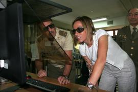
The ministress in the photogrammetry room (Photo:Ignacio Mohedano/Army Communication Department)
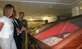
The ministress of Defence also visited the museum (Photo:Ignacio Mohedano/Army Communication Department)
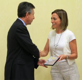
The moment of the presentation of the data base (Photo:Ignacio Mohedano/Army Communication Department)
The labour of conservation, custody and digitalisation undertaken by the Army Geographical Centre of the images of the Iberian Peninsula captured by the United States Army map service between 1956 and 1957 –known as American flight-, has made it possible for the ministress of Defence, Ms. Carme Chacón, to be able to present, on 7th September, the stills from this flight to the director general of the National Geographical Institute, Mr. Alberto Sereno.
The presentation ceremony was held at Geographical Centre installations and accompanying the ministress were the commander of the Information and Communication System Command, General Ferrández Aragüés, and the director of the Army Geographical Centre, Colonel García Lidón.
The transfer, which has come to fruition with the exchange of a data base including 59,000 stills conserved in 617 rolls, an 8 terabyte size, means that the Armed Forces 'grants all citizens the use of this material' so that it may be taken advantage of by all Government offices.
This document is the first complete map of Spain that has been conserved, and the Army Geological Centre, conscious of its importance from the viewpoint of topography, planimetry and spatial planning, began its digitalisation in 2003, which was concluded in 2009.
The American flight was a work of co-operation between the US and Spanish Armies that began on 3rd March 1956, and concluded on 15th September 1957. One of the copies was presented to the Army Geographical Centre, which has conserved it in a special, painstaking manner, which has made possible the delivery of an unabridged, digitised copy for public use within the National Cartography System.
Tour of the installations
Following the presentation ceremony, the ministress toured the workshop and printing areas, where works are undertaken of binding and printing maps, documents, etc.
Later, she visited a static display on the assets and resourses available to the Army Geographic Unit, the Geographic Information Headquarters photogrammetry room, where all maps of Spain and the areas of operations are periodically updated, the cartographic archive along with the museum area.
ARMY UNITS
- Araba Álava |
- Albacete |
- Alicante |
- Almería |
- Asturias |
- Ávila |
- Badajoz |
- Barcelona |
- Burgos |
- Cáceres |
- Cádiz |
- Cantabria |
- Castellón |
- Ceuta |
- Ciudad Real |
- Córdoba |
- A Coruña |
- Cuenca |
- Girona |
- Granada |
- Guadalajara |
- Gipuzkoa |
- Huelva |
- Huesca |
- Islas Baleares |
- Jaén |
- León |
- Lleida |
- Lugo |
- Madrid |
- Málaga |
- Melilla |
- Murcia |
- Navarra |
- Ourense |
- Palencia |
- Las Palmas |
- Pontevedra |
- La Rioja |
- Salamanca |
- Segovia |
- Sevilla |
- Soria |
- Tarragona |
- Santa Cruz de Tenerife |
- Teruel |
- Toledo |
- Valencia |
- Valladolid |
- Bizkaia |
- Zamora |
- Zaragoza
OUTSTANDING LINKS

Información
Mapa del sitio